Thursday, June 23, 2022

Odd Jobs and Diplomatic Interludes: Strange Comings and Goings in Northern Nigeria by Dogon Yaro (Ronald Bird)

 Returning to Northern Nigeria in 1946 on my second tour I was posted to Bornu Province. There were only three officers in the Province instead of the normal twelve. My job was ADO Provincial Office with a multitude of duties.

Demobilization was in hand and a hundred soldiers, recently returned from Burma, arrived in Maiduguri under the charge of two young British officers on their way up to Fort Lamy in Tchad. I sought permission to join them so that I could see what went on in our neighbouring French colony.
In Bornu and Adamawa
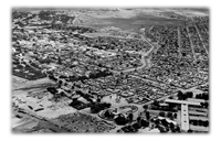
Fort Lamy

Lent the use of the UAC manager's house in Fort Lamy, we were there on Bastille Day. When we went to the Cercle or club everyone stood up, removed their hats, and we were thanked with a speech praising the British, and in particular the Nigerian Forces, for the help they had given in 1943. That was when the Free French under General LeClerc de Haute-Cloche had led an armoured brigade from the Gabon and the Cameroons across the Sahara through the Fezzan to take Rommel in the southern flank, while Montgomery was attacking Rommel from the east in Tunisia and the new American forces from the west. The British Army officers had no French, so I had to step in, making a speech in French in reply, which fortunately seemed to go down well.
Overland to Kano Across the Sahara
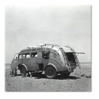
Broken Down in the Sahara

I was keen to find out more about the peoples in the French Territories. During the war the Free French ruled the Gabon, Cameroons and the Western Sudan, while the pro-German Vichy Petainists ruled Niger to the north and all the French colonies to the west. My next attempt to discover what went on over our frontiers was to cross the Sahara, a journey of some 2500 miles, from Algiers in the north, southwards to Kano in Northern Nigeria. I made the journey by bus, a large beetle-like vehicle with balloon tyres carrying six passengers and a ton and half of freight. After Tamanrasset in the Hoggar Mountains we began the toughest part of the desert crossing through sandy and rocky country, with large areas of soft sand, often getting stuck and having to dig ourselves out. After a few days we began to see herds of camels and cattle at large watering holes. At one of these I saw a group of Africans, obviously not Tuareg, sitting under a thorn tree. I spoke to them in Hausa and learned that they were Rahji Fulani with their cattle who often crossed the frontier between Niger and Northern Nigeria in search of the best pastures. I only had a few words of Fulani but they all spoke Hausa, and were intrigued to find a European speaking to them in an African language, as the French officials refused to study the local African languages. They admitted that they had to be careful not to spend long periods in Northern Nigeria or they would be caught for Jangali, the cattle tax.

In Kano I said goodbye to my fellow travellers, French engineers who were continuing on to Fort Lamy, a further 400 miles. I heard them refer to me as 'Ce type tres Squire'!

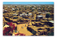
In 1960 when I was Senior District Officer in charge of Kano division we heard that the Emperor Hailie Selassie of Ethiopia was going to stop off at Kano airport for a day. In the absence of the Resident, who was in Kaduna, I was in charge. I met the Emperor at the airport. Accompanied by his daughter, he refused to speak to me, although he spoke good English, and insisted on issuing instructions to his daughter who would only pass them on to me in French. They wanted to see the old walled city of Kano but would not have time to visit the Emir. I took them to the parts of the city that could be visited by car, in particular three of the old gates that were still standing. I explained to them how Islam had come across to Kano in the 13th and 14th centuries, and how Kano had rivalled Timbuktu as the main trading entrepot south of the Sahara. Amongst other things we viewed the Emir's palace from the outside, and the mosque, a modern building built by the Public Works Department. Also of interest was the Sabon Gari, the new town area with canteens, railway depots and trading centres.
In Bornu and Adamawa
Kano

In October 1960 Nigeria achieved independence. We had good relations with the Premier of Northern Nigeria, the Sardauna of Sokotu, Alhaji Ahmadu Bello, who depended heavily on the remaining colonial officers for the new administration of Northern Nigeria. I was appointed Senior Acting Resident of Kano. So when Pandit Nehru and Mrs Gandhi, two eminent Indian politicians, had to make an unscheduled stop for a few hours in the middle of the night it was my duty as the senior government representative to look after them. This we did as best we could at the airport, although neither was prepared to talk much about international affairs. As it was still raining when their plane was ready to leave I had my car brought round to the front of the building. With my official driver at the wheel of the car I opened the passenger door for Pandit Nehru to get in and then went round to the other side to open the car door for Mrs Gandhi. She refused, saying, 'Mr Bird, you must get in first', and explaining that for security reasons she could only feel confident of her own safety if I got into the car before her.

1961 brought a visit from HRH Prince Philip, Duke of Edinburgh, who stopped off in Kano on his way to take the Independence Celebrations for Tanganyika. We were between Residencies at the time, posing a logistical challenge. The old mud built residency with its 15-foot high vaulted mud ceiling, though an impressive historic building resembling an emir's palace, was not suitable for putting up royalty, whereas the new Residency had an air-conditioned bedroom. I arranged for the local hotel manager and his staff to look after the royal party in the new Residency, while I gave a reception at the Old Residency so Prince Philip could thank the Commissioner of Police and the Superintendent who had provided an escort.

In 1961 we had a battalion of Belgian Paratroopers on their way home, camped at Kano airport, having handed over to the incoming United Nations peacekeeping forces in the Republic of the Congo. On the other side of the airport we had a battalion of African Mali troops going to the Congo. Fortunately the Nigerian police were able to keep them apart as the nearest units of the Nigerian army were some 130 miles away in Kaduna, so no use in an emergency.
In Bornu and Adamawa
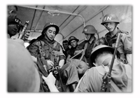
Irish UN troops

Not long after this we had an Irish Army battalion transit through Kano, on their way to join the UN forces in the Congo. The Colonel and a few officers came to a party at the Residency where they were amused to find that during the war I had served with the Regiment of Pearse, the Dublin College's local defence force who trained with the Irish army in the Wicklow Hills and went on manoeuvres through the back streets of north Dublin defending the city against a possible German invasion.

The Trinity College Dublin connection had proved equally useful when I was instructed to meet Mr Sean Lemass, the Prime Minister of Ireland, who was visiting Kano with the new Irish Ambassador Eamon Kennedy. He was most put out to find a white official receive him on behalf of the government of the recently independent Northern Nigeria. Mr Kennedy and I had met at the 1942 Regatta at Droghedra, where Trinity College Dublin were the victors at the rowing championships of Ireland, so he was able to reassure Mr Lemass that Ronnie Bird was a good sort and an Irishman at heart.

In 1962 the office of Resident was abolished and I was appointed Provincial Secretary with a Provincial Commissioner as the political head of Kano Province. This role fell to a friend of mine, The Honourable Alhaji Aliyu Magajin Gari Sokoto, whom I had known in Sokoto as a senior member of the Sultan's Council in 1957- 58. We got on well and as Provincial Secretary I continued with my normal duties while Alhaji was the figurehead nominally in charge.

In April 1963 it was time for me to say my goodbyes after twenty years working in Northern Nigeria. I was given a grand send-off led by Madakin Kano, a brilliant administrator, with the whole of the Emir's Council in support. The Nigeria Police Band played the moving tune of the Hausa Farewell and tears flowed on all sides.
Wednesday, June 22, 2022

Volcanoes, Earthquakes, and Crocodiles by David Bell (Geologist, British Solomon Islands Protectorate (BSIP) 1959-61)


Volcanoes, Earthquakes and Crocodiles
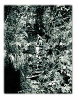
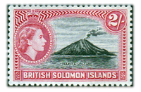
Tinakula Volcano
After finishing my DPhil at Oxford I applied to join the Colonial Geological Survey, hoping for a post in Fiji. None being available there, I accepted the offer of one in the Solomons. After all, they were in the Pacific too, if 2000km distant. My outward journey was one in which - as the size of the aircraft became smaller (Bristol Britannia to Sydney, Lockheed Constellation to Port Moresby, Douglas DC4 to Rabaul, DC3 to Honiara) the humidity grew greater. On landing at Henderson Field on Guadalcanal, accustomed as I was to the bleak mountains of Skye, I wondered how anyone could survive in this place.
Volcanoes, Earthquakes and Crocodiles
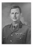
Brigadier Bomford

The Chief Geologist, on leave in Australia getting married, had left as my first job the making of a theodolite survey of the upraised coral terraces around Honiara in preparation for future housing developments. I had fortunately learned this skill from the legendary Brigadier Bomford, Reader in Geodesy at Oxford, by carrying out a survey of the University Parks. My next assignment was real geology: exploratory survey and mapping of the Betilonga district high in the mountains of Guadalcanal where there was the possibility of copper mineralisation. We had only the simplest of maps, drawn by the Survey draughtsman from American air photographs taken during the War. A complete cover of dense tropical rainforest leaves only the vaguest outlines of ridges and valleys and nothing of the complexity of the ground itself. The way of working in such country was by pace and compass traverse along the rivers and streams as far as their source, sampling where outcrops - if any - occur and subsequent extrapolation of geological boundaries between traverses. It takes a lot of time. I learned the survey methods from John Hill, the Rhodesian geologist who was nearing the end of his last tour, and the rules of survival in the jungle from the others in the team, the Solomon Islanders: teenage boys from the mountains who carried the loads, built the camps and cooked the food, all for £6 and a pound of plug tobacco per month, and the excellent Geological Assistants who had received a grammar school level education.

Volcanoes, Earthquakes and Crocodiles
John Grover's Survey Team

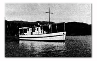
The basic work for any national Geological Survey is to produce geological maps of its entire territory while concurrently searching for economically significant mineral resources. The Chief Geologist, John Grover, now wished to extend this programme to the Western Solomons where no systematic geological survey had ever been attempted and Dick Stanton of New England University in Armidale, Australia and I were given the task. I sailed from Honiara in early August 1959 on the Survey's vessel Noula to set up a base camp on Oropie Island in the Wana Wana Lagoon (where John F Kennedy's patrol torpedo boat was rammed by a Japanese destroyer in August 1943). The Noula was a thirty-foot launch designed for ferry work in Sydney harbour but in the Solomons it regularly went on ocean-going journeys, like this one of 200 nautical miles, about 30 hours at cruising speed. On board we had two dug-out canoes strapped alongside, a 500 gallon water tank roped on the cabin roof, stores for two months, and 30 people: crew. Survey personnel and many family members including women and small children. Mercifully, the weather was benign. The Government's largest and newest vessel, the MV Melanesian, had disappeared on 10 July 1958 with 64 people on board. Its loss was never explained but a massive freak wave was one of the postulated reasons.

Volcanoes, Earthquakes and Crocodiles
MV Noula

By 18 August with the Oropie camp established I was sitting on the stern of the Noula, anchored offshore having breakfast when I heard shouting coming from the island. When I asked one of the crew what was going on he told me they were saying there was an earthquake happening. I had already felt several tremors in Honiara but this time, nothing. On a ship you don't because the sea damps out the motion. Then the ship's radio came on with the Chief Geologist telling me there had been a major earthquake with early indications of epicentre near where I was and several reports of heavy damage. I was to sail immediately for Gizo, the administrative centre for the Western Solomons, about four hours sail, and report back.

The earthquake measured 7.4 on the Richter scale then in use and caused widespread structural damage but no loss of life. Ground fissures opened, shorelines subsided and a seismic sea-wave swept away leaf houses in some coastal villages. Stanton and I saw the most spectacular effects when we traversed the island of Vella Lavella some time later. Large faults had been activated, causing landslides that destroyed swathes of jungle, clogging rivers and causing flooding. Hot springs appeared in some places and a thermal area of sulphur vents and mud pools increased significantly in size.

Volcanoes, Earthquakes and Crocodiles
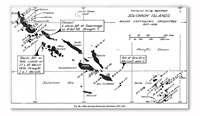
Seismic Activity, 1958

The Solomon Islands form one segment of a tectonically extremely complex region of the Pacific involving interactions between the Indo-Australian plate and the Western Pacific plate. Earthquakes (now monitored by the Survey's seismic station) are common and volcanoes, dormant and active, characterize the area. Savo Island volcano, 14km north of Guadalcanal, is potentially the most dangerous. Its last eruption, probably in about 1850, wiped out the entire population in pyroclastic flows of the kind that Vesuvius produced in AD 79, engulfing Pompeii. I made one visit to Savo to check gas compositions and temperatures of the array localities that the Survey established for monitoring the volcano. I visited two other Solomons volcanoes, one, Simbo in the West, by design and the other, also in the West, by accident. Activity on Simbo consists of hot springs and fumaroles (gas vents). Past activity has been explosive causing evacuation of the population at times. The other volcano was Kavachi, a submarine vent south of Vanguno Island at the eastern end of the New Georgia group. From time to time (most recently in 2014) it erupts and forms temporary Islands that are quickly washed away. One day in 1961 I was on board the Government ship Veronica en route to Munda when we must have sailed right over the Kavachi vent that exploded when the ship was about 500m away, sending up a massive fountain of boiling seawater filled with glowing pieces of lava. The skipper ordered full speed and we watched Kavachi repeat the performance several times before dusk fell. One day Kavachi may become one of the new permanent Solomon Islands.

Volcanoes, Earthquakes and Crocodiles
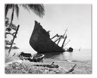
Abandoned Japanese Transports

Two non-geological experiences In the Solomons remain vivid in my memory. One relates to the War of which there were many signs remaining in 1959-61: beached Japanese transports, wrecked aircraft In the jungle, abandoned shattered barges half-sunk in estuaries. Just before leaving for the West, I was called on by the Police Chief. He told me that some Japanese soldiers had been seen foraging in a village garden on New Georgia. "You take a rifle with you," he said. I assented—It was a Lee Enfield .303 for protection against crocodiles. "Well, if you find them, bring them in, will you?" "What if I can't persuade them?" "Shoot the buggers." Fortunately we never saw them.

My other memory was of going with a crocodile shooter on one of his hunts, again in the Western Solomons where the salt-water crocodile Is common. Hunting was done after nightfall. A heavy dugout canoe carried three men, the hunter up front, the paddler at the stern and. In this case me, in the middle with a powerful lamp running off a car battery. The canoe went slowly along the riverbank with the lamp light sweeping the sides. A crocodile's eyes glow red in the light. The shooter stands up and aims between the eyes. The crocodile must then be secured alongside or In the canoe in case it sinks and is lost. That Is the really exciting part, or so I was told. We saw several sets of red eyes like car rear lights but the shooter judged all of the targets unsuitable: they were all too large to take on.

Tuesday, June 21, 2022

Volcanos, Earthquakes, and Crocodiles: British Solomon Islands Protectorate by David Bell (Geologist, British Solomon Islands Protectorate (BSIP) 1959-61)


Volcanoes, Earthquakes and Crocodiles
Tinakula Volcano
After finishing my DPhil at Oxford I applied to join the Colonial Geological Survey, hoping for a post in Fiji. None being available there, I accepted the offer of one in the Solomons. After all, they were in the Pacific too, if 2000km distant. My outward journey was one in which - as the size of the aircraft became smaller (Bristol Britannia to Sydney, Lockheed Constellation to Port Moresby, Douglas DC4 to Rabaul, DC3 to Honiara) the humidity grew greater. On landing at Henderson Field on Guadalcanal, accustomed as I was to the bleak mountains of Skye, I wondered how anyone could survive in this place.
Volcanoes, Earthquakes and Crocodiles
Brigadier Bomford

The Chief Geologist, on leave in Australia getting married, had left as my first job the making of a theodolite survey of the upraised coral terraces around Honiara in preparation for future housing developments. I had fortunately learned this skill from the legendary Brigadier Bomford, Reader in Geodesy at Oxford, by carrying out a survey of the University Parks. My next assignment was real geology: exploratory survey and mapping of the Betilonga district high in the mountains of Guadalcanal where there was the possibility of copper mineralisation. We had only the simplest of maps, drawn by the Survey draughtsman from American air photographs taken during the War. A complete cover of dense tropical rainforest leaves only the vaguest outlines of ridges and valleys and nothing of the complexity of the ground itself. The way of working in such country was by pace and compass traverse along the rivers and streams as far as their source, sampling where outcrops - if any - occur and subsequent extrapolation of geological boundaries between traverses. It takes a lot of time. I learned the survey methods from John Hill, the Rhodesian geologist who was nearing the end of his last tour, and the rules of survival in the jungle from the others in the team, the Solomon Islanders: teenage boys from the mountains who carried the loads, built the camps and cooked the food, all for £6 and a pound of plug tobacco per month, and the excellent Geological Assistants who had received a grammar school level education.

Volcanoes, Earthquakes and Crocodiles
John Grover's Survey Team

The basic work for any national Geological Survey is to produce geological maps of its entire territory while concurrently searching for economically significant mineral resources. The Chief Geologist, John Grover, now wished to extend this programme to the Western Solomons where no systematic geological survey had ever been attempted and Dick Stanton of New England University in Armidale, Australia and I were given the task. I sailed from Honiara in early August 1959 on the Survey's vessel Noula to set up a base camp on Oropie Island in the Wana Wana Lagoon (where John F Kennedy's patrol torpedo boat was rammed by a Japanese destroyer in August 1943). The Noula was a thirty-foot launch designed for ferry work in Sydney harbour but in the Solomons it regularly went on ocean-going journeys, like this one of 200 nautical miles, about 30 hours at cruising speed. On board we had two dug-out canoes strapped alongside, a 500 gallon water tank roped on the cabin roof, stores for two months, and 30 people: crew. Survey personnel and many family members including women and small children. Mercifully, the weather was benign. The Government's largest and newest vessel, the MV Melanesian, had disappeared on 10 July 1958 with 64 people on board. Its loss was never explained but a massive freak wave was one of the postulated reasons.

Volcanoes, Earthquakes and Crocodiles
MV Noula

By 18 August with the Oropie camp established I was sitting on the stern of the Noula, anchored offshore having breakfast when I heard shouting coming from the island. When I asked one of the crew what was going on he told me they were saying there was an earthquake happening. I had already felt several tremors in Honiara but this time, nothing. On a ship you don't because the sea damps out the motion. Then the ship's radio came on with the Chief Geologist telling me there had been a major earthquake with early indications of epicentre near where I was and several reports of heavy damage. I was to sail immediately for Gizo, the administrative centre for the Western Solomons, about four hours sail, and report back.

The earthquake measured 7.4 on the Richter scale then in use and caused widespread structural damage but no loss of life. Ground fissures opened, shorelines subsided and a seismic sea-wave swept away leaf houses in some coastal villages. Stanton and I saw the most spectacular effects when we traversed the island of Vella Lavella some time later. Large faults had been activated, causing landslides that destroyed swathes of jungle, clogging rivers and causing flooding. Hot springs appeared in some places and a thermal area of sulphur vents and mud pools increased significantly in size.

Volcanoes, Earthquakes and Crocodiles
Seismic Activity, 1958

The Solomon Islands form one segment of a tectonically extremely complex region of the Pacific involving interactions between the Indo-Australian plate and the Western Pacific plate. Earthquakes (now monitored by the Survey's seismic station) are common and volcanoes, dormant and active, characterize the area. Savo Island volcano, 14km north of Guadalcanal, is potentially the most dangerous. Its last eruption, probably in about 1850, wiped out the entire population in pyroclastic flows of the kind that Vesuvius produced in AD 79, engulfing Pompeii. I made one visit to Savo to check gas compositions and temperatures of the array localities that the Survey established for monitoring the volcano. I visited two other Solomons volcanoes, one, Simbo in the West, by design and the other, also in the West, by accident. Activity on Simbo consists of hot springs and fumaroles (gas vents). Past activity has been explosive causing evacuation of the population at times. The other volcano was Kavachi, a submarine vent south of Vanguno Island at the eastern end of the New Georgia group. From time to time (most recently in 2014) it erupts and forms temporary Islands that are quickly washed away. One day in 1961 I was on board the Government ship Veronica en route to Munda when we must have sailed right over the Kavachi vent that exploded when the ship was about 500m away, sending up a massive fountain of boiling seawater filled with glowing pieces of lava. The skipper ordered full speed and we watched Kavachi repeat the performance several times before dusk fell. One day Kavachi may become one of the new permanent Solomon Islands.

Volcanoes, Earthquakes and Crocodiles
Abandoned Japanese Transports

Two non-geological experiences In the Solomons remain vivid in my memory. One relates to the War of which there were many signs remaining in 1959-61: beached Japanese transports, wrecked aircraft In the jungle, abandoned shattered barges half-sunk in estuaries. Just before leaving for the West, I was called on by the Police Chief. He told me that some Japanese soldiers had been seen foraging in a village garden on New Georgia. "You take a rifle with you," he said. I assented—It was a Lee Enfield .303 for protection against crocodiles. "Well, if you find them, bring them in, will you?" "What if I can't persuade them?" "Shoot the buggers." Fortunately we never saw them.

My other memory was of going with a crocodile shooter on one of his hunts, again in the Western Solomons where the salt-water crocodile Is common. Hunting was done after nightfall. A heavy dugout canoe carried three men, the hunter up front, the paddler at the stern and. In this case me, in the middle with a powerful lamp running off a car battery. The canoe went slowly along the riverbank with the lamp light sweeping the sides. A crocodile's eyes glow red in the light. The shooter stands up and aims between the eyes. The crocodile must then be secured alongside or In the canoe in case it sinks and is lost. That Is the really exciting part, or so I was told. We saw several sets of red eyes like car rear lights but the shooter judged all of the targets unsuitable: they were all too large to take on.